I couldn't resist a quick post about another possible winter weather event. Not only did Sir Walter Wally, our resident winter weather predictor, predict another 6 weeks of winter, he brings tidings of COLD and SNOW this week.
From WRAL: "The Triangle and areas to the north can expect anywhere from a dusting of snow to 2 inches, WRAL meteorologist Mike Maze said. Northern counties have the best shot at snow, but there likely won't be enough moisture behind the cold front to keep snow falling steadily Tuesday morning.... For the morning commute, it's unlikely that there'll be many problems on the roads, Maze said, given the warm temperatures of the past few days that has heated up highways.
WRAL Chief Meteorologist Greg Fishel said that Wednesday's commute could be more troubled, since temperatures will be lower, in the 20s.
More places will have a chance to see snow than on Tuesday. Flakes might be seen as far as Fayetteville during the morning commute."
I love the idea of snow, but not when it could affect my commute. I can't afford to add on any more 'adverse weather' time at work - I'm saving all my leave for more important things!
Monday, February 02, 2009

Tuesday, January 20, 2009
Snow? Oh yeah, we have it.
We were not disappointed this morning, snow covers the ground. We're both home from work and just finished a nice big breakfast (eggs, bacon, grits & blueberries). I think a mid-morning nap is in order before we take a little walk outside. I have to guess we've got about 4 inches and it's still falling like mad. I doubt we'll get anywhere near the record 2000 snowfall (21 inches), but it's the most I've seen in a LONG time. Here's a few pictures.
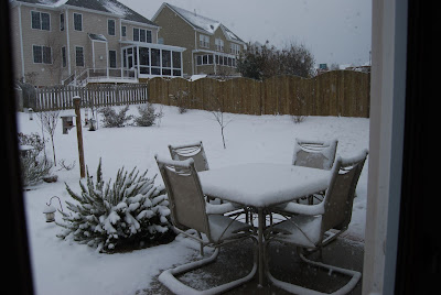
Taken from inside the house as it's still falling/blowing like crazy!
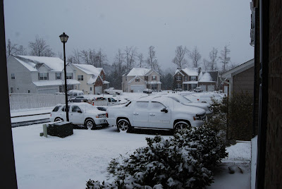
Looking down the street as the Town snowplows our road.
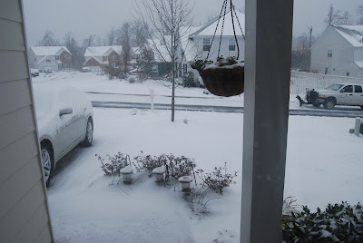
I had no idea they would plow our street! See truck, far right.
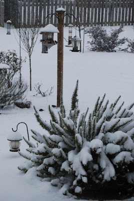
The birds need more seed!
Taken from inside the house as it's still falling/blowing like crazy!
Looking down the street as the Town snowplows our road.
I had no idea they would plow our street! See truck, far right.
The birds need more seed!
Monday, January 19, 2009
Afternoon snow update
Well, the sun was shining this afternoon and it was vaguely warm. However, I can see some snowy looking clouds on the horizon. WRAL has the latest on the possible winter weather -

"The Triangle could take the brunt of a snowstorm pressing toward the Carolinas, the National Weather Service forecast indicates.
The heaviest band of snow is forecast along the U.S. Highway 1 corridor, from Southern Pines to Raleigh and east to Rocky Mount and Nashville. Accumulation to the south and east of the Triangle could reach 6 inches.
...
Whatever wintry precipitation falls is likely to stick around for a while – particularly on roads – because North Carolina won't see a significant warm-up until the latter part of the week.
The winter storm predicted for Jan. 19-20 comes during an auspicious – or infamous – time for snow in the Triangle.
Four years ago to the day, between 0.5 and 2 inches fell on central North Carolina, catching everyone by surprise. Roads clogged up with workers and students going home early, clogging roads at the same time they turned icy and making some commutes last more than eight hours. About 3,000 Wake County students were stranded at schools overnight.
Five years earlier, on Jan. 25, 2000, the region got its heaviest snowfall ever, 4 inches shy of 2 feet."
Ah, I remember both storms well. The 2005 storm caught me at work and I had to crawl out to the RDU airport to pick up Paul late that afternoon. It took us several hours to get home that night taking a jammed I-540 to Six Forks Road (Falls of Neuse & Capital Blvd north were completely shut down because of the hills near the Neuse River bridges). I know that we wouldn't have made it without the all-wheel-drive Subaru. She was only a few weeks old and she proved her worth that night! W hile many other cars were ditched on slick hilly roads, we made it home! The 2000 storm happened while I was away for college. Asheville saw about 4 inches (fun) but my parents were completely homebound in Raleigh. During that time they got some crazy cabin fever and thought it would be grand to call and tell me crazy things. I shall leave such crazy things unsaid.
Here's hoping for some fluffy white stuff! The pantry, fridge & freezer are stocked!
"The Triangle could take the brunt of a snowstorm pressing toward the Carolinas, the National Weather Service forecast indicates.
The heaviest band of snow is forecast along the U.S. Highway 1 corridor, from Southern Pines to Raleigh and east to Rocky Mount and Nashville. Accumulation to the south and east of the Triangle could reach 6 inches.
...
Whatever wintry precipitation falls is likely to stick around for a while – particularly on roads – because North Carolina won't see a significant warm-up until the latter part of the week.
The winter storm predicted for Jan. 19-20 comes during an auspicious – or infamous – time for snow in the Triangle.
Four years ago to the day, between 0.5 and 2 inches fell on central North Carolina, catching everyone by surprise. Roads clogged up with workers and students going home early, clogging roads at the same time they turned icy and making some commutes last more than eight hours. About 3,000 Wake County students were stranded at schools overnight.
Five years earlier, on Jan. 25, 2000, the region got its heaviest snowfall ever, 4 inches shy of 2 feet."
Ah, I remember both storms well. The 2005 storm caught me at work and I had to crawl out to the RDU airport to pick up Paul late that afternoon. It took us several hours to get home that night taking a jammed I-540 to Six Forks Road (Falls of Neuse & Capital Blvd north were completely shut down because of the hills near the Neuse River bridges). I know that we wouldn't have made it without the all-wheel-drive Subaru. She was only a few weeks old and she proved her worth that night! W hile many other cars were ditched on slick hilly roads, we made it home! The 2000 storm happened while I was away for college. Asheville saw about 4 inches (fun) but my parents were completely homebound in Raleigh. During that time they got some crazy cabin fever and thought it would be grand to call and tell me crazy things. I shall leave such crazy things unsaid.
Here's hoping for some fluffy white stuff! The pantry, fridge & freezer are stocked!
Winter Storm Watch!
Whoa Nellie! We wake up to find we're under a winter storm watch tonight and tomorrow with the chance of 2-4-6 inches of snow! Yesterday it was cold and drizzly with a little sleet. It was quite depressing. Now we're on SNOW WATCH 2009! I'm about to be off to the grocery store to pick up a few things - mostly because we never made it to the store this weekend and our pantry is bare.
... Winter Storm Watch in effect from this evening through Tuesday
afternoon...
The National Weather Service in Raleigh has issued a Winter Storm
Watch... which is in effect from this evening through Tuesday
afternoon.
A strong upper level disturbance will dive southward through the
Midwest today... and eastward through the Carolinas tonight and
Tuesday. Low pressure at the surface is expected to develop over
western South Carolina this evening and intensify rapidly as it
tracks east then northeast along the North Carolina coast tonight
through Tuesday. With cold air in place over central North
Carolina... the potential exists for a significant amount of snow as
this storm system strengthens.
Precipitation is expected to begin as a mix of rain and snow this
evening... transitioning quickly to all snow overnight... continuing
through Tuesday. Storm total snowfall is expected to be at least two
inches across the area... and could reach four to six inches by
Tuesday evening in some locations.
Some uncertainty remains regarding the precise location of the
highest snowfall totals. At this time it appears that the greatest
risk of heavy snow will be in the corridor between Highway one and
Interstate 95. However... everyone across central North Carolina
should keep a close eye on the latest conditions and forecasts
through today and tonight. Check NOAA Weather Radio or other local
media frequently for the latest information... including possible
advisories and warnings... on this developing storm.
A Winter Storm Watch means there is a potential for significant
snow... sleet... or ice accumulations that may impact travel.
Continue to monitor the latest forecasts.

... Winter Storm Watch in effect from this evening through Tuesday
afternoon...
The National Weather Service in Raleigh has issued a Winter Storm
Watch... which is in effect from this evening through Tuesday
afternoon.
A strong upper level disturbance will dive southward through the
Midwest today... and eastward through the Carolinas tonight and
Tuesday. Low pressure at the surface is expected to develop over
western South Carolina this evening and intensify rapidly as it
tracks east then northeast along the North Carolina coast tonight
through Tuesday. With cold air in place over central North
Carolina... the potential exists for a significant amount of snow as
this storm system strengthens.
Precipitation is expected to begin as a mix of rain and snow this
evening... transitioning quickly to all snow overnight... continuing
through Tuesday. Storm total snowfall is expected to be at least two
inches across the area... and could reach four to six inches by
Tuesday evening in some locations.
Some uncertainty remains regarding the precise location of the
highest snowfall totals. At this time it appears that the greatest
risk of heavy snow will be in the corridor between Highway one and
Interstate 95. However... everyone across central North Carolina
should keep a close eye on the latest conditions and forecasts
through today and tonight. Check NOAA Weather Radio or other local
media frequently for the latest information... including possible
advisories and warnings... on this developing storm.
A Winter Storm Watch means there is a potential for significant
snow... sleet... or ice accumulations that may impact travel.
Continue to monitor the latest forecasts.
Subscribe to:
Posts (Atom)